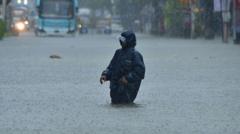
In the wake of Typhoon Danas, which claimed two lives and left a staggering 600,000 households without power in Taiwan, the storm has shifted to affect southern China and Hong Kong. The tropical depression is expected to bring torrential rains and flash flooding, leading authorities to take precautionary measures, including the temporary closure of schools in Hong Kong.
Following its initial landfall in Taiwan earlier this week, Danas crossed the Taiwan Strait and caused significant damage, resulting in widespread outages and disruption. As the system moved into China’s southeastern regions, it was downgraded but continued to unleash heavy rain, with forecasts predicting up to three inches of rain per hour as it progresses southward toward Guangdong province, home to approximately 127 million residents.
Guangdong's meteorological center has raised concerns about flash flooding, landslides, and other potential hazards, cautioning residents to remain vigilant. Alongside heavy rains, thunderstorms and wind gusts reaching 73 miles per hour, akin to a Category 1 hurricane, have been predicted, amplifying fears of severe storms affecting both urban and rural areas.
In Hong Kong, the remnants of Typhoon Danas are expected to collide with existing monsoon rains, exacerbating the situation. The local weather agency has issued a red rain warning, indicating a risk of over 1.9 inches of rainfall per hour, leading to disruptions of daily life and compelling residents to remain indoors for safety. Wind gusts have already been documented at 43 miles per hour on nearby Sha Chau Island, prompting further warnings that violent gusts could impact the metropolis.
As the storm's aftermath continues to unfold, officials are urging residents to prepare for the worst of the weather conditions expected to linger through Friday.