Hurricane Erin has rapidly escalated to a category five hurricane, boasting wind speeds of 160 mph, with potential risks including heavy rainfall and hazardous surf along the East Coast of the United States.
Hurricane Erin Surges to Category Five Status, Threatening East Coast

Hurricane Erin Surges to Category Five Status, Threatening East Coast
Tropical cyclone strengthens drastically, posing risks of flooding and dangerous surf conditions.
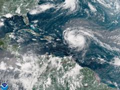
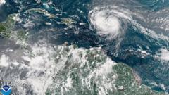
A satellite image captured Hurricane Erin as it advanced in the Atlantic Ocean, showcasing its alarming intensification. The National Hurricane Center's Director Mike Brennan stated during a recent briefing that the storm has "explosively deepened and intensified" from tropical storm status as of Friday night. Erin is anticipated to skirt north of the Leeward Islands, Virgin Islands, and Puerto Rico this weekend, possibly unleashing up to 6 inches (15 cm) of rain. This raises the likelihood of flash flooding and mudslides in affected areas. Notably, Erin marks the beginning of the 2025 Atlantic hurricane season and is not expected to make landfall on the mainland United States at this time.
The phenomenon of rapid intensification describes the storm's process of increasing wind speed by 34 mph within 24 hours. According to Mr. Brennan, Erin's winds surged from 100 mph earlier on Saturday morning to a staggering 160 mph. As the storm continues its path next week, it is projected to gradually move northward, veering past the east of the Bahamas and heading towards the Outer Banks of North Carolina.
The storm's impact will extend beyond just rainfall, with life-threatening surf and rip currents expected along almost the entire East Coast of the U.S. Florida and the mid-Atlantic states are alerted to the most severe surf conditions, and Bermuda may experience similar threats, including heavy rain. In light of the storm's gale force winds, the U.S. Coast Guard has enacted restrictions on vessel movements in the ports located in St. Thomas and St. John in the U.S. Virgin Islands, along with six municipalities in Puerto Rico, including San Juan.
The National Oceanic and Atmospheric Administration (NOAA), the leading U.S. weather agency, has forecasted an "above normal" hurricane season for the Atlantic. Climate predictions suggest an increase in the frequency of tropical storms reaching category four and five classifications, a trend attributed to global warming.


