
In brief
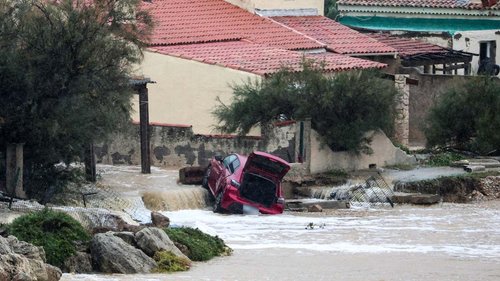
Heavy rains from a powerful storm over the southwestern United States forced authorities in Arizona, Colorado, New Mexico and Utah to issue evacuation orders on Sunday. The storm, which continues to drop rain through Monday, has left already saturated ground vulnerable to rapid runoff and flash flooding, particularly in steep canyons and former wildfire areas. These states are still recovering from devastating floods that occurred earlier this week, leaving lingering risks.
A powerful storm struck the southwestern United States on Sunday, bringing heavy rainfall to parts of Arizona, Colorado, New Mexico, and Utah. The storm forced local authorities in those states to issue evacuation orders on Monday, 2 November 2026, as a response to growing concerns about flash flooding.
Storm Details
The precipitation was described by meteorologists as intense, with the Weather Prediction Center reporting that the storm unleashed heavy rain across the region. The rains fell on soil that had become saturated from recent flooding events triggered days earlier. Because the ground was already holding maximum moisture, the additional rainfall was forecast to produce rapid runoff.
Evacuation Orders and Warning Scope
Arizona issued evacuation orders for several communities in the Southwest part of the state through postal codes that had previously experienced flash floods. Colorado’s emergency management departments ordered evacuations in southwestern counties, while New Mexico’s state police and Utah’s Governor’s office announced directives for residents living in low-lying and canyon areas. The orders were issued proactively to mitigate the risk of sudden water surges in narrow valleys.
Risk Factors and Vulnerable Areas
The warnings highlighted that steep terrain, narrow canyons, and stream channels were particularly susceptible to flooding. In areas that had been affected by wildfires in recent weeks, the lack of vegetation further heightened the chance of uncontrolled runoff. Ground that was already saturated from prior floods posed an additional danger, as new rain could turn dry hillsides into dangerous torrents.
Meteorological Forecast
Climate experts from the Weather Prediction Center projected that the threat of flash flooding could continue through Monday. They stressed that the combination of heavy rainfall and saturated soil was expected to persist, potentially triggering further rapid runoff events in affected regions.
Background of Recent Flooding
The Southwest states had faced devastating floods earlier in November, which created a fragile environment. The Western New Mexico and southern Utah areas had already suffered severe flooding, leaving communities to rebuild infrastructure. The new storm adds to the ongoing stress on emergency resources and cities that are still in recovery mode.
Wildfire and Steep Terrain Concerns
Authorities emphasized that wildfire-affected regions were particularly at risk due to the loss of vegetation that normally acts as a buffer during heavy rain. The steep canyon walls prone to erosion could experience surging streams, especially where channel banks have been weakened by fire damage.
Uncertainties Remain
While meteorologists warned of continuing risk through Monday, there remains uncertainty about the precise timing and severity of potential flash flooding. The evolving weather patterns mean that exact outcomes are still indeterminate. The extent to which saturated soils will translate into sudden runoff lacks firm quantitative data at this stage, underscoring the unreliability of current projections for specific local areas.